
Overcoming social exclusion. Helping a
fishing village to build digital community resilience and adapt to the changing world.
ROLE: UX Design
TEAM: CIVIS LLC, Helena R, JunChen Y
CLIENT: Ko Panyi
YEAR: Jun - Nov 2020


Project Checklist
The project started with ambiguity. The client presented us with an opportunity to engage with the locals, familiarize ourselves with the local culture, and produce situated proposals (in any practical medium) that will help the community to adapt to the increasingly fast-paced, changing world.
_Page_16.jpg)
_Page_17.jpg)
_Page_21.jpg)
_Page_22.jpg)
_Page_23.jpg)
Ethnography:
Understanding the Community

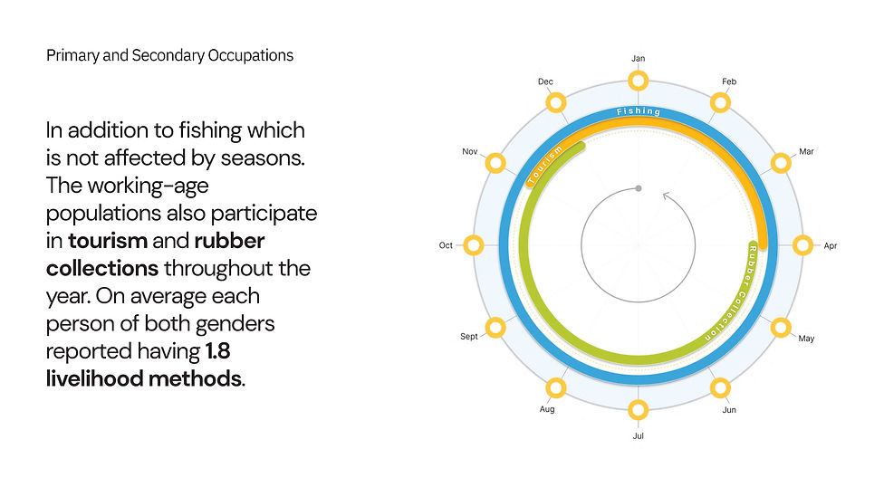
The learning outcome of the ethnography research was amazing. Not only did we learn about motivations behind the villager's behavioral patterns, but we were also exposed to local perspectives on subjects such as:
-
Conflict with recently implemented MPAs (Marine Protected Areas policy) and how it has negatively impacted small, isolated communities.
-
Tourism is gradually becoming the primary source of income for the community because fishing is disrupted by climate change and policy interventions.
-
Internally some villagers think that community decision-making processes need to be more transparent, and more people should be informed about the community's plan for the future.
-
Local Residents are incredibly resourceful and highly self-initiated builders. Through community collaboration and teamwork, they have managed to bring in electricity and internet access.
In reality, I collected much more community, villager-specific challenges. I used the analytic tool AirTable to dynamically examine the relationship between the logged challenge and associated data points through careful analysis of remote interview sessions and additional qualitative interactions. In the following, I will illustrate how I funnel available data to extrapolate actionable digital transformations.


Evaluating Challenges and Prioritizing Transformations
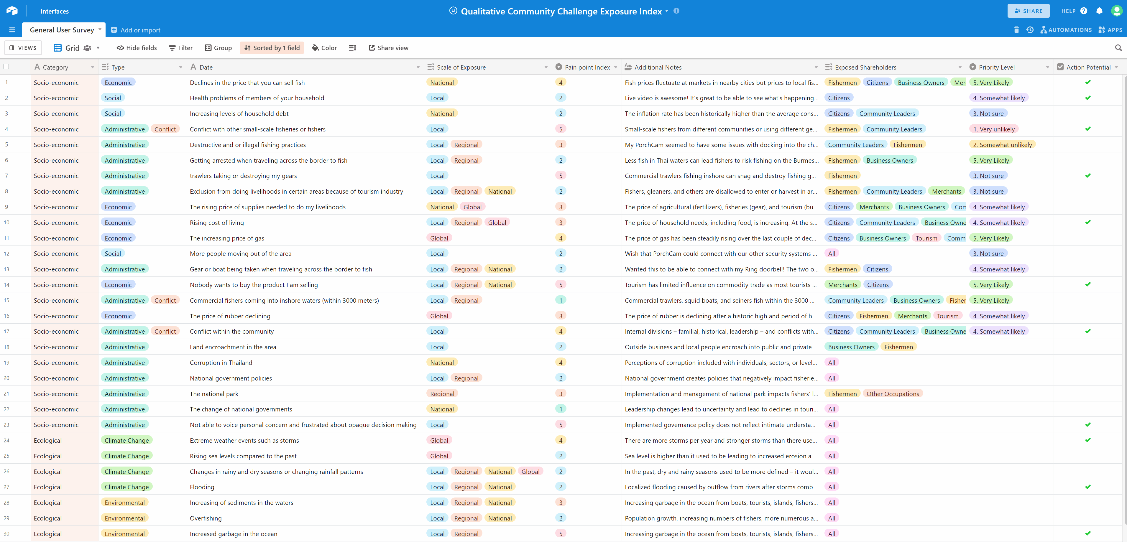
AirTable is a very powerful, flexible tool that allowed me to organize detailed user data and re-examine the entries by dynamic shifting evaluation priorities. By sorting the data-points using different sets of filters we can identify the following latent attributes of each logged community, villager challenge such:
-
Immediacy: How many stakeholders do the challenge impact (ex. residents, business owners, etc.)
-
Scope of Impact: Does the listed challenge affect only local villagers or have a regional or international impact? This helps me to gauge whether the issue can be engaged Practically.
-
Nature of the Impact: Whether the challenge is ecological, socio-economical, or administrative?
-
Conflict: Whether the challenge induces inter-personal conflicts.
-
Digital Potential: Different problems require different solutions. It is most important for me to understand which challenges can be addressed through minimal digital intervention while achieving maximum impact.
In short summary, I have Identified and cataloged
30+
Unique community challenges
6
Additional attribute data points for each challenge
(Category/Type/Scale of Exposure/Pain Point Index/Exposed Stakeholders/Action Potentials)
11
Actionable digital transformations

Storyboard V.S. User Journey

While Human-centric design conventions call for a complete user journey to further cement empathy, I decided to divest more effort into creating an elaborate storyboard instead.
My reasons for this step of the project are:
-
Interview data on AirTable has already communicated nuanced aspects of the villagers' daily lives
-
The client is very graphically oriented and because of different levels of technical familiarity a narrative-based presentation is more likely to effectively communicate product vision
-
Finding similarities among different stakeholders is more important than sculpting an individual user's behavioral patterns. In this instance, I believe that achieving community-level understanding is critical for this project.
Information Architecture

Guided by the 4 design principles, the information architecture of CODAS is designed with 3 functional layers:
-
Community-level announcements (local highlights, new discussion topics, and weather alerts)
-
User-group specific functions (group announcements, community trading platform)
-
User-specific features (Chat, transportation, community voting, etc.)
Swiss knife, not Chef knife
In the case of CODAS the villagers do not desire single-feature complexity as the tasks they need to automate are relatively simple. Instead, they want a digital swiss knife that can provide them with various contextually situated solutions. That is why I proposed the following community-specific features:
-
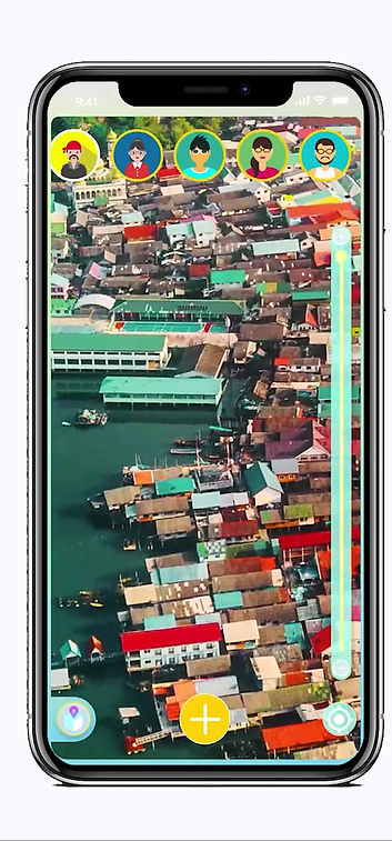
Map-based, Spatially oriented information hub: live local highlights interface informing residents, business owners, and tourists about the latest community highlights.
-
Live Community Expansion Monitor: Ko Panyi villagers are DIY experts, and the village needs frequent construction and maintenance for its public-private facilities. Having a live view of ongoing projects can help the residents to keep track and contribute to ongoing projects.
-
Community Trading Platform: The community can benefit from optimized supply circulation because of the rising cost of resources. We believe it would be much more cost-effective to enable the villagers to build a common digital supply warehouse and circulate supply internally.
-
Collective Voting: This feature design was motivated by the villagers' desire to increase decision-making transparency and the opportunity to engage in community discussions. Nobody wants decisions made behind their back, and that is why a collective decision-making feature can help the residents stay informed and build trust within the community.
-
Transportation: As gas prices rise further, the local fishers, tour guides can save costs by digitizing/automating the local transportation network.


And of course, lots and lots of design and iterations.
Interactive Prototypes and Animated User Stories

As a part of the final deliverables, I designed 5 fully animated interactive prototypes. User case scenarios such as:
-
Local Highlights Browsing
-
Public Voting on co-design activities
-
Community expansion
-
Internal Trading
-
Transporation
By using visual and interactive storytelling, I hope to communicate to the potential users of our product vision to help them and their community facilitate community activities, optimize management, and build trust. It is my hope that the villagers can preserve their unique local culture through CODAS while adapting to the rapidly changing world.

1. Local Highlights
Target Users: Ko Panyi citizens, Business Owners, Tourists
It is important for both local citizens and foreign tourists to know what is going on during the day. No one wants to miss fresh-caught seafood and other exciting activities such as music festivals or scenic boat rides. CODAS's real-time highlights interface allows the users to share their moments with the public!

2. Collective Voting
Target Users: Ko Panyi citizens, Business Owners
Local decisions should be made locally. It is vital for the Ko Panyi citizens to be able to cast their own votes in community matters. CODAS takes that into consideration and translates it into a three-step process: start a poll, cast a vote, and count the vote.


1
2
3
Poll
Vote
Count


3. Community Expansion Monitor
Target Users: Ko Panyi citizens, Business Owners
Unlike other fishing communities with access to developed regions, Ko Panyi must rely on locally sourced materials and villagers' participation to expand/upgrade communal facilities. CODAS allows the citizens to keep track of local projects and contribute necessary material if available. We hope that this feature can enable the citizens to become more actively involved with local infrastructure efforts.


4. Daily Trading and Exchange
Target Users: Ko Panyi citizens
Things come from somewhere. In Ko Panyi's case, the citizens often have to rely on each others' resources. That is why CODAS has its own unique, value-flexible trading system in which the users can freely purchase/sell and request necessary materials for their everyday life.


Between-Island Transport
Local Transport
5. Water Transport
Target Users: Ko Panyi citizens, tourists
In Ko Panyi, boats are the only mean of transportation. While there are many docks located around the village, having accessible real-time water transport availability will further increase transport accessibility around the village and help the tourists to better navigate between the scenic sites.
Conclusions and Takeaways
Phew! That was it—a community-scale platform from SCRATCH. I am incredibly grateful to have this opportunity to engage with such a unique challenge. I especially enjoyed the ethnographic research phase, and I appreciate the chance to learn from such unique culture. Ko Panyi is a lovely place, and I hope that I get to visit and say "สวัสดี (Hi)" in-person one day. That being said, there are also aspects of the project that I would like to reflect upon.
-
If I had more time:
-
I would like to spend more time with the interviewees (by proxy through the translator) and more thoroughly document their daily lives and experience
-
I would love to do a Diary Study of a 3-6 days span to understand further the villagers' experience when facing their pain points. A complete Diary Study can allow me to construct a collection of holistic user personas and user journey mapping.
-
-
If I can do it again:
-
Due to internal constraints, I was limited by certain stylistic choices that I understand do not comply with visual accessibility standards. Should I have the opportunity to re-design the interface, I would choose high text to background contrast palette, and colors that are friendly to users who are color-blind.
-